
Occurrence record: BRI AQ0970495
Preserved specimen
of
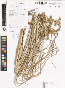
Cyperus javanicus
Houtt.
| Java Sedge
recorded on 2015-06-07
Images
Dataset
| Data partner | Australia's Virtual Herbarium |
| Data resource | BRI AVH Data and Images |
| Institution code |
Queensland Department of Environment and Science
Supplied institution code "BRI" |
| Collection |
Queensland Herbarium
Supplied collection code "Herbrecs" |
| Catalog number | BRI AQ0970495 |
| Occurrence ID | urn:catalog:BRI:Herbrecs:0970495 |
| Record type |
Preserved specimen
Supplied basis "PreservedSpecimen" |
| Preparations | Sheet |
| Collector |
1.
Mcdonald, K.R.
2.
Bassani, L.
Supplied as "McDonald, K.R.;Bassani, L." |
| Record number | KRM17235 |
| Associated Occurrence Status | Representative record |
| Associated occurrences |
This record has 1 inferred associated occurrences
For more information see Inferred associated occurrence details |
| License | CC-BY 4.0 (Int) |
| Presence/Absence | PRESENT Supplied as present |
| Associated records | REPRESENTATIVE |
| Occurrence remarks | Tufted sedge 1.2m. |
Event
| Occurrence date | 2015-06-07 |
| Event remarks | Scarce. |
| Date precision | DAY |
Taxonomy
| Higher classification | Plantae | Viridaeplantae | Streptophyta | Equisetopsida | Magnoliidae | Lilianae | Poales | Cyperaceae | Cyperus |
| Scientific name | Cyperus javanicus |
| Identified to rank | species |
| Common name | Java Sedge |
| Kingdom | Plantae |
| Phylum |
Charophyta
Supplied as "Streptophyta" |
| Class | Equisetopsida |
| Order | Poales |
| Family | Cyperaceae |
| Genus | Cyperus |
| Species | Cyperus javanicus |
| Name match metric | exactMatch |
| Scientific name authorship | Houtt. |
| Name parse type | SCIENTIFIC |
| Nomenclatural code | ICN |
Geospatial
| Higher geography | Australia, Queensland, Cook |
| Country | Australia |
| State or Territory | Queensland |
| Locality | Lama Lama National Park, Bull Swamp. |
| Habitat |
Supplied as "Edge of seasonal swamp, Melaleuca leucadendra woodland." |
| Latitude |
-14.396667 Supplied as: "-14.3966666667" |
| Longitude |
143.728056 Supplied as: "143.7280555556" |
| Datum |
EPSG:4326 Supplied datum: "WGS84" |
| Coordinate precision | Unknown |
| Coordinate uncertainty (in metres) | 100.0 |
| Georeference protocol | GPS |
| County | Cook |
| Terrestrial | true |
| Biome | TERRESTRIAL |
| Marine | false |
| Country Code | AU |
Additional properties
| verbatim identification | Det. |
Data quality tests
| Test name | Result |
| Coordinate rounded | Warning |
| Show/Hide 95 passed properties | |
| Show/Hide 4 missing properties | |
| Show/Hide 24 tests that have not been run | |
Inferred associated occurrence details
This record has been identified as the representative occurrence in a group of associated occurrences. This mean other records have been detected that seem to relate to this record and this particular record has the most detailed information on the occurrence. More information about the duplication detection methods and terminology in use is available here:
| Representative Record | |||
| Record UUID | 4ba09326-1c3a-4398-87ce-47db1c476ef6 | ||
| Data Resource | BRI AVH Data and Images | ||
| Raw Scientific Name | Cyperus javanicus | ||
| Coordinates | -14.396667,143.728056 | ||
| Related records | |||
| Record UUID | e742db98-ad70-4bae-a473-68b5ef91bccf | ||
| Data Resource | Northern Territory Herbarium (DNA) AVH data | ||
| Raw Scientific Name | Cyperus javanicus Houtt. | ||
| Coordinates | -14.396667,143.728056 | ||

